What mistake did al-Idrisi make regarding Europe?
He omitted Scandinavia
He connected it to Africa
He showed it as landlocked
He underestimated its size
Answer
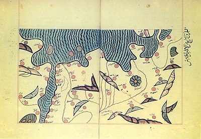
Al-Idrisi, a 12th-century Arab geographer, underestimated the size of Europe. His map of the world, known as the Tabula Rogeriana, depicted Europe as much smaller than it actually is. This error likely stemmed from a lack of accurate information about the continent at the time. Despite this mistake, al-Idrisi's map was a significant contribution to medieval cartography and provided valuable insights into the geographical knowledge of the period.

Mapping the Medieval World: The Adventures of Muhammad al-Idrisi
Related Quizzes


Subscribe Now!
Learn something
new everyday
Playing quizzes is free! We send 1 quiz every week to your inbox